
Make a donation
Gear up for your next adventure:
As an Amazon Associate, this site earns from qualifying purchases at no extra cost to you.
Messier Channel topographic map
Click on the map to display elevation.
Make a donation
Gear up for your next adventure:
As an Amazon Associate, this site earns from qualifying purchases at no extra cost to you.
About this map
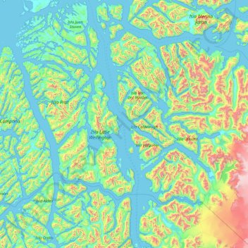
Name: Messier Channel topographic map, elevation, terrain.
Average elevation: 951 ft
Minimum elevation: -7 ft
Maximum elevation: 5,778 ft
Make a donation
Gear up for your next adventure:
As an Amazon Associate, this site earns from qualifying purchases at no extra cost to you.
Other topographic maps
Click on a map to view its topography, its elevation and its terrain.
Lookout at Mount Fitzroy
Chile > Aysén Region > Provincia de Capitán Prat > O’Higgins
Average elevation: 2,156 ft
Glaciar Chico
Chile > Aysén Region > Provincia de Capitán Prat > O’Higgins
Average elevation: 4,859 ft
Make a donation
Gear up for your next adventure:
As an Amazon Associate, this site earns from qualifying purchases at no extra cost to you.