
Cerro de Silla topographic map
Interactive map
Click on the map to display elevation.
About this map
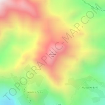
Name: Cerro de Silla topographic map, elevation, terrain.
Location: Cerro de Silla, Municipio Andrés Eloy Blanco, Lara, Venezuela (9.75515 -69.43000 9.75525 -69.42990)
Average elevation: 4,859 ft
Minimum elevation: 3,363 ft
Maximum elevation: 6,178 ft
Other topographic maps
Click on a map to view its topography, its elevation and its terrain.
Carora
Venezuela > Lara > Municipio Torres
Carora, Parroquia Trinidad Samuel, Municipio Torres, Lara, Venezuela
Average elevation: 1,634 ft
Las Tunitas
Venezuela > Lara > Municipio Iribarren
Las Tunitas, Parroquia Tamaca, Municipio Iribarren, Lara, Venezuela
Average elevation: 1,942 ft
Barquisimeto
Venezuela > Lara > Barquisimeto
Barquisimeto, Municipio Iribarren, Lara, 3001, Venezuela
Average elevation: 2,274 ft
La Economía
Venezuela > Lara > La Economía
La Economía, Municipio Urdaneta, Lara, Venezuela
Average elevation: 1,007 ft