Geolocate

Berthoud topographic map

Click on the map to display elevation.

About this map

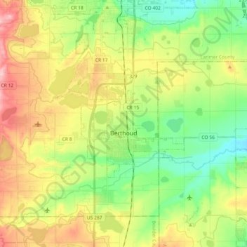
Name: Berthoud topographic map, elevation, terrain.

Location: Berthoud, Larimer County, Colorado, United States (40.27751 -105.13124 40.34932 -104.95025)

Average elevation: 5,072 ft

Minimum elevation: 4,865 ft

Maximum elevation: 5,364 ft

Colorado trails, hiking, mountain biking, running and outdoor activities

Gear up for your next adventure:

🏥Hiking First Aid Kits - Comprehensive medical kits for remote trail injuries
🛏️Cold Weather Sleeping Bag - Warm sleeping bag for cold conditions
GPS Sports Watch - GPS watch for running, hiking and training
🥾Women's Hiking Boots - Top-rated trail boots with ankle support and superior grip
🦺Reflective Outdoor Gear - Safety gear for low‑light conditions

As an Amazon Associate, this site earns from qualifying purchases at no extra cost to you.