
Make a donation
Gear up for your next adventure:
As an Amazon Associate, this site earns from qualifying purchases at no extra cost to you.
Ourense topographic map
Click on the map to display elevation.
Make a donation
Gear up for your next adventure:
As an Amazon Associate, this site earns from qualifying purchases at no extra cost to you.
Ourense
The ancient city of Auria is located on both banks of the Miño river in the south-central part of Galicia, at an elevation of 128 meters above sea level.
Make a donation
Gear up for your next adventure:
As an Amazon Associate, this site earns from qualifying purchases at no extra cost to you.
About this map
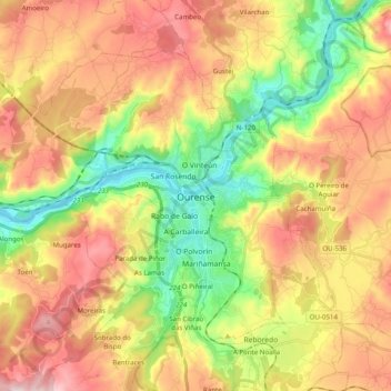
Name: Ourense topographic map, elevation, terrain.
Location: Ourense, Galicia, Spain (42.28951 -8.00350 42.39830 -7.80595)
Average elevation: 1,070 ft
Minimum elevation: 285 ft
Maximum elevation: 2,113 ft
Make a donation
Gear up for your next adventure:
As an Amazon Associate, this site earns from qualifying purchases at no extra cost to you.
Other topographic maps
Click on a map to view its topography, its elevation and its terrain.
Make a donation
Gear up for your next adventure:
As an Amazon Associate, this site earns from qualifying purchases at no extra cost to you.