
Make a donation
Gear up for your next adventure:
As an Amazon Associate, this site earns from qualifying purchases at no extra cost to you.
Beverly Hills topographic map
Click on the map to display elevation.
Make a donation
Gear up for your next adventure:
As an Amazon Associate, this site earns from qualifying purchases at no extra cost to you.
About this map
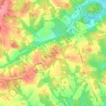
Name: Beverly Hills topographic map, elevation, terrain.
Location: Beverly Hills, Pickens County, South Carolina, United States (34.88012 -82.56985 34.92012 -82.52985)
Average elevation: 1,027 ft
Minimum elevation: 856 ft
Maximum elevation: 1,175 ft
Pickens County trails, hiking, mountain biking, running and outdoor activities
Make a donation
Gear up for your next adventure:
As an Amazon Associate, this site earns from qualifying purchases at no extra cost to you.
Other topographic maps
Click on a map to view its topography, its elevation and its terrain.
Jocassee Gorges Wildlife Management Area
United States > South Carolina > Pickens County
Average elevation: 1,726 ft
Make a donation
Gear up for your next adventure:
As an Amazon Associate, this site earns from qualifying purchases at no extra cost to you.