Geolocate

Denice topographic map

Click on the map to display elevation.

About this map

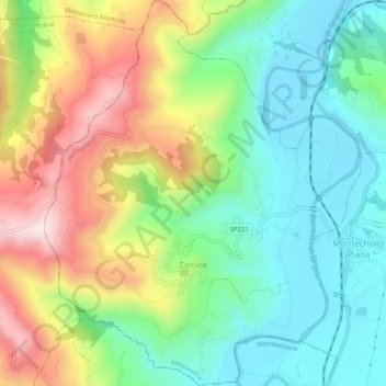
Name: Denice topographic map, elevation, terrain.

Location: Denice, Alessandria, Piedmont, Italy (44.58771 8.31398 44.62311 8.35486)

Average elevation: 1,158 ft

Minimum elevation: 587 ft

Maximum elevation: 2,139 ft

Other topographic maps

Click on a map to view its topography, its elevation and its terrain.

Po

Italy > Piedmont > Alessandria > Coniolo

Average elevation: 479 ft

Rosingo

Italy > Piedmont > Alessandria > Cerrina Monferrato

Average elevation: 768 ft

Valle Scura

Italy > Piedmont > Alessandria > Brignano-Frascata

Average elevation: 1,299 ft

Molini

Italy > Piedmont > Alessandria > Fraconalto

Average elevation: 2,047 ft

Zanco

Italy > Piedmont > Alessandria > Villadeati

Average elevation: 791 ft

Ciglione

Italy > Piedmont > Alessandria > Ponzone

Average elevation: 1,270 ft

Gnocchetto

Italy > Piedmont > Alessandria > Ovada

Average elevation: 1,401 ft

Mandrogne

Italy > Piedmont > Alessandria > Alessandria

Average elevation: 394 ft

Incisa

Italy > Piedmont > Alessandria > Montacuto

Average elevation: 1,749 ft

Gear up for your next adventure:

🏫Relief Map Kits - Hands-on tools for teaching landforms and elevation
🔊Portable Camp Speaker - Music and alerts at camp
🧦Hiking Socks - Comfortable socks to prevent blisters on long hikes
🌎3D Topographic Globes - Raised relief globes for a tactile understanding of geography
🖼️Topo Map Wall Art - Decorative topographic prints of famous peaks and regions

As an Amazon Associate, this site earns from qualifying purchases at no extra cost to you.