
Wahmbeckerheide topographic map
Interactive map
Click on the map to display elevation.
About this map
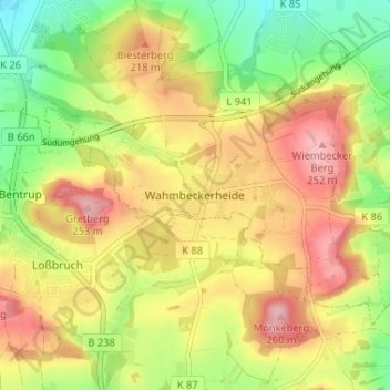
Name: Wahmbeckerheide topographic map, elevation, terrain.
Average elevation: 617 ft
Minimum elevation: 384 ft
Maximum elevation: 837 ft
Other topographic maps
Click on a map to view its topography, its elevation and its terrain.
32657
Deutschland > Nordrhein-Westfalen > Kreis Lippe > Lemgo > Entrup
32657, Lemgo, Entrup, Lemgo, Kreis Lippe, Nordrhein-Westfalen, Deutschland
Average elevation: 407 ft
Vogelhorst
Deutschland > Nordrhein-Westfalen > Kreis Lippe > Lemgo > Voßheide
Vogelhorst, Voßheide, Lemgo, Kreis Lippe, Nordrhein-Westfalen, 32657, Deutschland
Average elevation: 469 ft
Lüerdisser Bruch
Deutschland > Nordrhein-Westfalen > Kreis Lippe > Lemgo > Lüerdissen
Lüerdisser Bruch, Lüerdissen, Lemgo, Kreis Lippe, Nordrhein-Westfalen, 32657, Deutschland
Average elevation: 696 ft
Luherheide
Deutschland > Nordrhein-Westfalen > Kreis Lippe > Lemgo > Lüerdissen
Luherheide, Lemgo, Lüerdissen, Lemgo, Kreis Lippe, Nordrhein-Westfalen, 32657, Deutschland
Average elevation: 558 ft
Lieme
Deutschland > Nordrhein-Westfalen > Kreis Lippe > Lemgo
Lieme, Lemgo, Kreis Lippe, Nordrhein-Westfalen, Deutschland
Average elevation: 328 ft
Windelstein
Deutschland > Nordrhein-Westfalen > Kreis Lippe > Lemgo
Windelstein, Lemgo, Kreis Lippe, Nordrhein-Westfalen, Deutschland
Average elevation: 787 ft
Wiembeck
Deutschland > Nordrhein-Westfalen > Kreis Lippe > Lemgo
Wiembeck, Lemgo, Kreis Lippe, Nordrhein-Westfalen, Deutschland
Average elevation: 545 ft