
Colyford topographic map
Interactive map
Click on the map to display elevation.
About this map
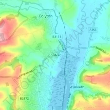
Name: Colyford topographic map, elevation, terrain.
Location: Colyford, East Devon, Devon, Angleterre, EX24 6QJ, Royaume-Uni (50.70628 -3.08477 50.74628 -3.04477)
Average elevation: 148 ft
Minimum elevation: -23 ft
Maximum elevation: 545 ft
Other topographic maps
Click on a map to view its topography, its elevation and its terrain.
Exmouth
Royaume-Uni > Angleterre > Devon > East Devon
Exmouth, East Devon, Devon, Angleterre, Royaume-Uni
Average elevation: 95 ft