
Sunshine Lake topographic map
Interactive map
Click on the map to display elevation.
About this map
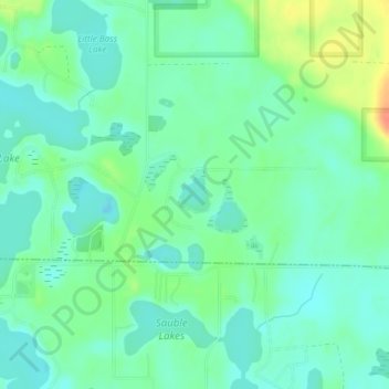
Name: Sunshine Lake topographic map, elevation, terrain.
Average elevation: 781 ft
Minimum elevation: 735 ft
Maximum elevation: 883 ft
Other topographic maps
Click on a map to view its topography, its elevation and its terrain.
Irons
United States > Michigan > Lake County
Irons, Eden Township, Lake County, Michigan, 49644, United States
Average elevation: 863 ft
Peacock
United States > Michigan > Lake County
Peacock, Peacock Township, Lake County, Michigan, United States
Average elevation: 902 ft
Sauble
United States > Michigan > Lake County
Sauble, Sauble Township, Lake County, Michigan, United States
Average elevation: 745 ft
Lake Township
United States > Michigan > Lake County
Lake Township, Lake County, Michigan, 49394, United States
Average elevation: 830 ft
Yates Township
United States > Michigan > Lake County
Yates Township, Lake County, Michigan, 49642, United States
Average elevation: 938 ft