
Subligna topographic map
Interactive map
Click on the map to display elevation.
About this map
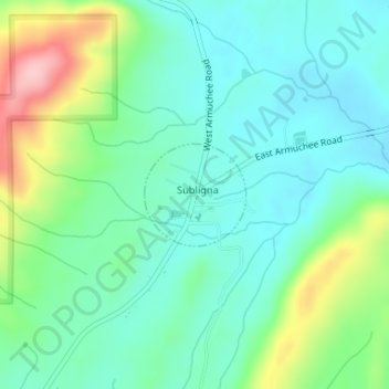
Name: Subligna topographic map, elevation, terrain.
Location: Subligna, Chattooga County, Georgia, United States (34.55642 -85.19246 34.56352 -85.18390)
Average elevation: 860 ft
Minimum elevation: 705 ft
Maximum elevation: 1,270 ft
Other topographic maps
Click on a map to view its topography, its elevation and its terrain.
Cloudland
United States > Georgia > Chattooga County
Cloudland, Chattooga County, Georgia, 30731, United States
Average elevation: 1,430 ft
Lyerly
United States > Georgia > Chattooga County
Lyerly, Chattooga County, Georgia, United States
Average elevation: 650 ft
Menlo
United States > Georgia > Chattooga County
Menlo, Chattooga County, Georgia, United States
Average elevation: 817 ft
Trion
United States > Georgia > Chattooga County
Trion, Chattooga County, Georgia, 30753, United States
Average elevation: 719 ft
Summerville
United States > Georgia > Chattooga County
Summerville, Chattooga County, Georgia, 30747, United States
Average elevation: 712 ft