
Gersheim topographic map
Interactive map
Click on the map to display elevation.
About this map
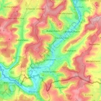
Name: Gersheim topographic map, elevation, terrain.
Location: Gersheim, Saarpfalz-Kreis, Saarland, 66453, Duitsland (49.11499 7.15897 49.19465 7.31027)
Average elevation: 994 ft
Minimum elevation: 656 ft
Maximum elevation: 1,342 ft
Other topographic maps
Click on a map to view its topography, its elevation and its terrain.
Homburg
Duitsland > Saarland > Saarpfalz-Kreis
Homburg, Saarpfalz-Kreis, Saarland, 66424, Duitsland
Average elevation: 932 ft