
Cocora topographic map
Interactive map
Click on the map to display elevation.
About this map
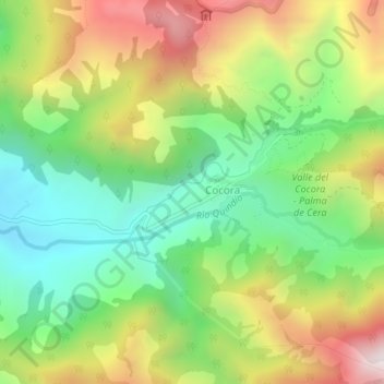
Name: Cocora topographic map, elevation, terrain.
Location: Cocora, Salento, Fría, Quindío, RAP Eje Cafetero, Colombie (4.61757 -75.50746 4.65757 -75.46746)
Average elevation: 8,714 ft
Minimum elevation: 7,192 ft
Maximum elevation: 11,079 ft
Other topographic maps
Click on a map to view its topography, its elevation and its terrain.
La Virginia
La Virginia, Calarcá, Capital, Quindío, RAP Eje Cafetero, 632001, Colombie
Average elevation: 5,509 ft
Rio Quindio
Rio Quindio, Armenia, Quindío, 630008, Colombie
Average elevation: 3,921 ft