
Make a donation
Gear up for your next adventure:
As an Amazon Associate, this site earns from qualifying purchases at no extra cost to you.
Saint Martin (France) topographic map
Click on the map to display elevation.
Make a donation
Gear up for your next adventure:
As an Amazon Associate, this site earns from qualifying purchases at no extra cost to you.
About this map
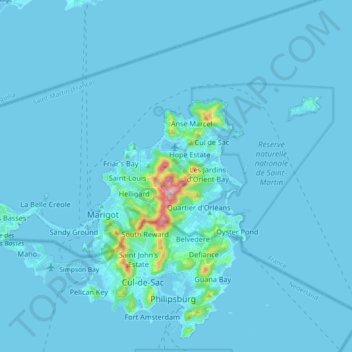
Name: Saint Martin (France) topographic map, elevation, terrain.
Location: Saint Martin (France), 97150, France (18.04659 -63.15334 18.12520 -62.97034)
Average elevation: 49 ft
Minimum elevation: -7 ft
Maximum elevation: 1,355 ft
Make a donation
Gear up for your next adventure:
As an Amazon Associate, this site earns from qualifying purchases at no extra cost to you.
Other topographic maps
Click on a map to view its topography, its elevation and its terrain.
Make a donation
Gear up for your next adventure:
As an Amazon Associate, this site earns from qualifying purchases at no extra cost to you.
Make a donation
Gear up for your next adventure:
As an Amazon Associate, this site earns from qualifying purchases at no extra cost to you.
Make a donation
Gear up for your next adventure:
As an Amazon Associate, this site earns from qualifying purchases at no extra cost to you.
Make a donation
Gear up for your next adventure:
As an Amazon Associate, this site earns from qualifying purchases at no extra cost to you.
Make a donation
Gear up for your next adventure:
As an Amazon Associate, this site earns from qualifying purchases at no extra cost to you.
Les Résidences
France > Auvergne-Rhône-Alpes > Puy-de-Dôme > Murat-le-Quaire
Average elevation: 3,517 ft
Siaugues-Saint-Romain
France > Auvergne-Rhône-Alpes > Haute-Loire > Siaugues-Sainte-Marie
Average elevation: 3,120 ft
Make a donation
Gear up for your next adventure:
As an Amazon Associate, this site earns from qualifying purchases at no extra cost to you.
Make a donation
Gear up for your next adventure:
As an Amazon Associate, this site earns from qualifying purchases at no extra cost to you.
Aix-en-Provence
France > Provence-Alpes-Côte d'Azur > Bouches-du-Rhône > Aix-en-Provence
Average elevation: 915 ft
Make a donation
Gear up for your next adventure:
As an Amazon Associate, this site earns from qualifying purchases at no extra cost to you.
Tré-le-Champ - le Haut
France > Auvergne-Rhône-Alpes > Upper Savoy > Chamonix-Mont-Blanc
Average elevation: 5,699 ft
Les Baux
France > Pays de la Loire > Loire-Atlantique > Vair-sur-Loire > Saint-Herblon
Average elevation: 164 ft
Make a donation
Gear up for your next adventure:
As an Amazon Associate, this site earns from qualifying purchases at no extra cost to you.
La Grave de Peille
France > Provence-Alpes-Côte d'Azur > Maritime Alps > Peille
Average elevation: 1,312 ft
Make a donation
Gear up for your next adventure:
As an Amazon Associate, this site earns from qualifying purchases at no extra cost to you.
Make a donation
Gear up for your next adventure:
As an Amazon Associate, this site earns from qualifying purchases at no extra cost to you.
Make a donation
Gear up for your next adventure:
As an Amazon Associate, this site earns from qualifying purchases at no extra cost to you.
Tré-le-Champ - le Bas
France > Auvergne-Rhône-Alpes > Upper Savoy > Chamonix-Mont-Blanc > Tré-le-Champ - le Bas
Average elevation: 5,656 ft
Make a donation
Gear up for your next adventure:
As an Amazon Associate, this site earns from qualifying purchases at no extra cost to you.
Moulin de Bel Air
France > Brittany > Finistère > Brélès > Moulin de Bel Air
Average elevation: 131 ft
Make a donation
Gear up for your next adventure:
As an Amazon Associate, this site earns from qualifying purchases at no extra cost to you.
Le Planet
France > Auvergne-Rhône-Alpes > Chamonix-Mont-Blanc > Argentière > Le Planet
Average elevation: 5,486 ft
Make a donation
Gear up for your next adventure:
As an Amazon Associate, this site earns from qualifying purchases at no extra cost to you.
Paris
Paris in its early history had only the rivers Seine and Bièvre for water. From 1809, the Canal de l'Ourcq provided Paris with water from less-polluted rivers to the north-east of the capital. From 1857, the civil engineer Eugène Belgrand, under Napoleon III, oversaw the construction of a series of new…
Average elevation: 246 ft
Pierrefitte-Nestalas
France > Occitania > Hautes Pyrenees > Pierrefitte-Nestalas > Pierrefitte-Nestalas
Average elevation: 2,336 ft
La Touche Bourdon
France > Pays de la Loire > Mayenne > Sacé > La Touche Bourdon
Average elevation: 351 ft
Make a donation
Gear up for your next adventure:
As an Amazon Associate, this site earns from qualifying purchases at no extra cost to you.
Make a donation
Gear up for your next adventure:
As an Amazon Associate, this site earns from qualifying purchases at no extra cost to you.
La Teste-de-Buch
France > New Aquitaine > Gironde > La Teste-de-Buch > La Teste-de-Buch
Average elevation: 39 ft
Make a donation
Gear up for your next adventure:
As an Amazon Associate, this site earns from qualifying purchases at no extra cost to you.
Make a donation
Gear up for your next adventure:
As an Amazon Associate, this site earns from qualifying purchases at no extra cost to you.
Mont Rachet
France > Bourgogne-Franche-Comté > Saône-et-Loire > La Salle > Mont Rachet
Average elevation: 633 ft
Make a donation
Gear up for your next adventure:
As an Amazon Associate, this site earns from qualifying purchases at no extra cost to you.
Gamay
France > Bourgogne-Franche-Comté > Saône-et-Loire > Saint-Sernin-du-Bois > Gamay
Average elevation: 1,378 ft
Les Ansaults
France > Centre-Loire Valley > Indre-et-Loire > Artannes-sur-Indre > Les Ansaults
Average elevation: 240 ft
Make a donation
Gear up for your next adventure:
As an Amazon Associate, this site earns from qualifying purchases at no extra cost to you.
Eget Village
France > Occitania > Hautes Pyrenees > Aragnouet > Eget Village
Average elevation: 5,118 ft
Le Suquet
France > Provence-Alpes-Côte d'Azur > Maritime Alps > Lantosque > Le Suquet
Average elevation: 2,195 ft
Make a donation
Gear up for your next adventure:
As an Amazon Associate, this site earns from qualifying purchases at no extra cost to you.
Le Petit Cirey
France > Bourgogne-Franche-Comté > Côte-d'Or > Cirey-lès-Nolay
Average elevation: 1,365 ft
Clau de Lagleyse
France > New Aquitaine > Lot-et-Garonne > Thézac > Clau de Lagleyse
Average elevation: 663 ft
Luchon-Superbagnères
France > Occitania > Haute-Garonne > Saint-Aventin > Luchon-Superbagnères
Average elevation: 4,367 ft
Make a donation
Gear up for your next adventure:
As an Amazon Associate, this site earns from qualifying purchases at no extra cost to you.
Le Revest-les-Eaux
France > Provence-Alpes-Côte d'Azur > Var > Le Revest-les-Eaux > Le Revest-les-Eaux
Average elevation: 1,073 ft
La Maranche
France > Auvergne-Rhône-Alpes > Loire > Saint-Bonnet-le-Courreau > La Maranche
Average elevation: 2,933 ft
Make a donation
Gear up for your next adventure:
As an Amazon Associate, this site earns from qualifying purchases at no extra cost to you.
La Pommeraye
France > Bourgogne – Franche-Comté > Saône-et-Loire > Beaurepaire-en-Bresse
Average elevation: 689 ft
Make a donation
Gear up for your next adventure:
As an Amazon Associate, this site earns from qualifying purchases at no extra cost to you.