
Gornji Milanovac topographic map
Interactive map
Click on the map to display elevation.
About this map
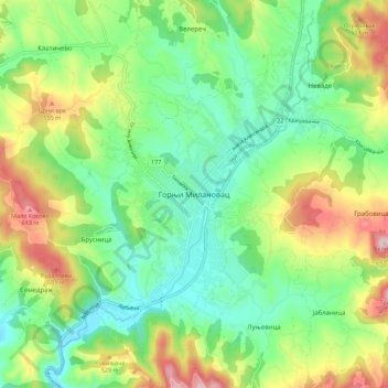
Name: Gornji Milanovac topographic map, elevation, terrain.
Average elevation: 1,352 ft
Minimum elevation: 912 ft
Maximum elevation: 2,185 ft
Other topographic maps
Click on a map to view its topography, its elevation and its terrain.
Dragolj
Serbia > Central Serbia > Moravica Administrative District > Gornji Milanovac Municipality
Dragolj, Gornji Milanovac Municipality, Moravica Administrative District, Central Serbia, Serbia
Average elevation: 958 ft