
городское поселение Тырныауз topographic map
Interactive map
Click on the map to display elevation.
About this map
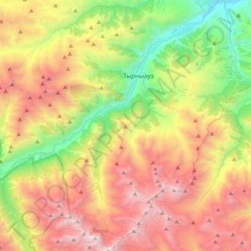
Name: городское поселение Тырныауз topographic map, elevation, terrain.
Average elevation: 8,333 ft
Minimum elevation: 3,474 ft
Maximum elevation: 14,442 ft
Other topographic maps
Click on a map to view its topography, its elevation and its terrain.
Сарыкол
Russland > Kabardino-Balkarien > Rajon Elbrusski
Сарыкол, сельское поселение Верхний Баксан, Rajon Elbrusski, Kabardino-Balkarien, Föderationskreis Nordkaukasus, 361609, Russland
Average elevation: 8,320 ft