
Make a donation
Gear up for your next adventure:
As an Amazon Associate, this site earns from qualifying purchases at no extra cost to you.
Laoshan District topographic map
Click on the map to display elevation.
Make a donation
Gear up for your next adventure:
As an Amazon Associate, this site earns from qualifying purchases at no extra cost to you.
Laoshan District
The district belongs to north temperature zone, with a monsoon-influenced temperate climate. There is neither intense heat in summer nor severe cold in winter. Most of the district is highland with the average altitude of 55m and surface water of 3m. There is abundant high quality ground water. In fact, Laoshan mineral water is renowned and sold China-wide. Natural resources are abundant, with granite being the prevalent mineral in the area.
Make a donation
Gear up for your next adventure:
As an Amazon Associate, this site earns from qualifying purchases at no extra cost to you.
About this map
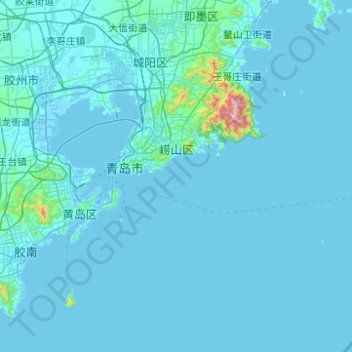
Name: Laoshan District topographic map, elevation, terrain.
Location: Laoshan District, Qingdao, Shandong, 266100, China (35.74544 120.40589 36.34086 121.39600)
Average elevation: 75 ft
Minimum elevation: -10 ft
Maximum elevation: 3,547 ft
Make a donation
Gear up for your next adventure:
As an Amazon Associate, this site earns from qualifying purchases at no extra cost to you.
Other topographic maps
Click on a map to view its topography, its elevation and its terrain.
Make a donation
Gear up for your next adventure:
As an Amazon Associate, this site earns from qualifying purchases at no extra cost to you.