
Thank you for supporting this site ❤️
Make a donation
Make a donation
Gear up for your next adventure:
As an Amazon Associate, this site earns from qualifying purchases at no extra cost to you.
Eben am Achensee topographic map
Click on the map to display elevation.
Thank you for supporting this site ❤️
Make a donation
Make a donation
Gear up for your next adventure:
As an Amazon Associate, this site earns from qualifying purchases at no extra cost to you.
About this map
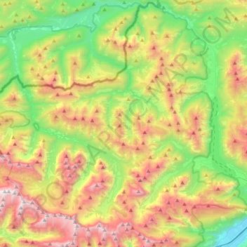
Name: Eben am Achensee topographic map, elevation, terrain.
Location: Eben am Achensee, Bezirk Schwaz, Tyrol, Austria (47.38074 11.44933 47.56787 11.78199)
Average elevation: 4,596 ft
Minimum elevation: 1,716 ft
Maximum elevation: 8,868 ft
Thank you for supporting this site ❤️
Make a donation
Make a donation
Gear up for your next adventure:
As an Amazon Associate, this site earns from qualifying purchases at no extra cost to you.