
Pabianice topographic map
Interactive map
Click on the map to display elevation.
About this map
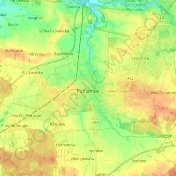
Name: Pabianice topographic map, elevation, terrain.
Location: Pabianice, Pabianice County, Łódzkie Voivodship, Poland (51.63224 19.27419 51.69920 19.43554)
Average elevation: 614 ft
Minimum elevation: 538 ft
Maximum elevation: 689 ft
Other topographic maps
Click on a map to view its topography, its elevation and its terrain.
Pawłówek
Poland > Łódzkie Voivodship > Pabianice County
Pawłówek, gmina Dłutów, Pabianice County, Łódzkie Voivodship, 95-081, Poland
Average elevation: 650 ft
Lutomiersk
Poland > Łódzkie Voivodship > Pabianice County
Lutomiersk, gmina Lutomiersk, Pabianice County, Łódzkie Voivodship, 95-083, Poland
Average elevation: 541 ft