Geolocate

Potterne topographic map

Click on the map to display elevation.

About this map

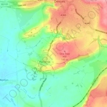
Name: Potterne topographic map, elevation, terrain.

Location: Potterne, Wiltshire, England, United Kingdom (51.30762 -2.04336 51.35085 -1.96713)

Average elevation: 302 ft

Minimum elevation: 177 ft

Maximum elevation: 502 ft

Gear up for your next adventure:

🚗GPS Dash Cams - Record your scenic drives through mountain passes and canyons
📱Heavy-Duty Phone Cases - Drop-proof and waterproof protection for outdoor navigation
👟Men's Trail Runners - Lightweight footwear for fast-paced exploration and light hiking
🦺Reflective Outdoor Gear - Safety gear for low‑light conditions
🔥Camping Stove - Portable stove for camping and backcountry cooking

As an Amazon Associate, this site earns from qualifying purchases at no extra cost to you.