
Thank you for supporting this site ❤️
Make a donation
Make a donation
Gear up for your next adventure:
As an Amazon Associate, this site earns from qualifying purchases at no extra cost to you.
Cheraga topographic map
Click on the map to display elevation.
Thank you for supporting this site ❤️
Make a donation
Make a donation
Gear up for your next adventure:
As an Amazon Associate, this site earns from qualifying purchases at no extra cost to you.
About this map
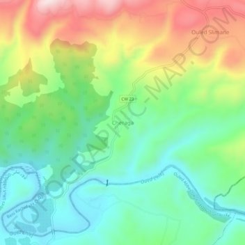
Name: Cheraga topographic map, elevation, terrain.
Location: Cheraga, Beni Rachid, Daïra Oued Fodda, Chlef, Algérie (36.23341 1.50482 36.27341 1.54482)
Average elevation: 945 ft
Minimum elevation: 407 ft
Maximum elevation: 1,900 ft
Thank you for supporting this site ❤️
Make a donation
Make a donation
Gear up for your next adventure:
As an Amazon Associate, this site earns from qualifying purchases at no extra cost to you.