
Thank you for supporting this site ❤️
Make a donation
Make a donation
Gear up for your next adventure:
As an Amazon Associate, this site earns from qualifying purchases at no extra cost to you.
Bemposta topographic map
Click on the map to display elevation.
Thank you for supporting this site ❤️
Make a donation
Make a donation
Gear up for your next adventure:
As an Amazon Associate, this site earns from qualifying purchases at no extra cost to you.
About this map
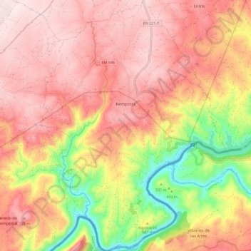
Name: Bemposta topographic map, elevation, terrain.
Location: Bemposta, Mogadouro, Bragança District, 5200-055, Portugal (41.26404 -6.54001 41.34965 -6.45558)
Average elevation: 1,975 ft
Minimum elevation: 1,066 ft
Maximum elevation: 2,536 ft
Thank you for supporting this site ❤️
Make a donation
Make a donation
Gear up for your next adventure:
As an Amazon Associate, this site earns from qualifying purchases at no extra cost to you.