
Sahline topographic map
Interactive map
Click on the map to display elevation.
About this map
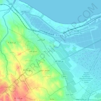
Name: Sahline topographic map, elevation, terrain.
Location: Sahline, Monastir, Tunisie (35.70173 10.66750 35.78134 10.77691)
Average elevation: 59 ft
Minimum elevation: -10 ft
Maximum elevation: 272 ft
Other topographic maps
Click on a map to view its topography, its elevation and its terrain.
Zaouit Kontech
Tunisie > Monastir > Zaouit Kontech
Zaouit Kontech, Zaouiet Kontoch, Jammel, Monastir, 5028, Tunisie
Average elevation: 112 ft
Amirat Hojjaj
Tunisie > Monastir > Amirat Hojjaj
Amirat Hojjaj, Amiret El Hojjaj, Moknine, Monastir, Tunisie
Average elevation: 184 ft