
Raymondville topographic map
Interactive map
Click on the map to display elevation.
About this map
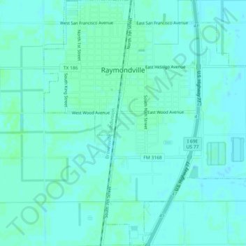
Name: Raymondville topographic map, elevation, terrain.
Location: Raymondville, Willacy County, Texas, 78580, United States (26.45230 -97.79775 26.49299 -97.75638)
Average elevation: 39 ft
Minimum elevation: 30 ft
Maximum elevation: 46 ft
Other topographic maps
Click on a map to view its topography, its elevation and its terrain.
Padre Island National Seashore
United States > Texas > Willacy County > Corpus Christi
Padre Island National Seashore, Corpus Christi, Willacy County, Texas, 78418, United States
Average elevation: 16 ft
Port Mansfield
United States > Texas > Willacy County
Port Mansfield, Willacy County, Texas, 78598, United States
Average elevation: 10 ft