
Ricketts Glen State Park topographic map
Interactive map
Click on the map to display elevation.
About this map
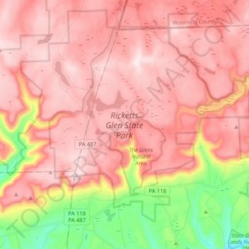
Name: Ricketts Glen State Park topographic map, elevation, terrain.
Average elevation: 1,929 ft
Minimum elevation: 925 ft
Maximum elevation: 2,464 ft
The state's original plans for the new park included building an inn, an 18-hole golf course and country club, and a winter sports complex for skiing, ice boating, and tobogganing, as well as a beach with bathing facilities, cabins, and a tent camping area. Only the last three were actually built, all south of Lake Jean; the Hayfield area north of Lake Jean was to have had the facilities for golf and tennis, and the inn and winter sports complex were to have been atop Cherry Ridge, at an elevation of 2,461 feet (750 m).
Other topographic maps
Click on a map to view its topography, its elevation and its terrain.
Lake Leigh Dam (defunct)
United States > Pennsylvania > Luzerne County > Fairmount Township
Lake Leigh Dam (defunct), Fairmount Township, Luzerne County, Pennsylvania, United States
Average elevation: 2,205 ft
Red Rock
United States > Pennsylvania > Luzerne County > Fairmount Township
Red Rock, Fairmount Township, Luzerne County, Pennsylvania, United States
Average elevation: 1,437 ft