
Ruatapu topographic map
Interactive map
Click on the map to display elevation.
About this map
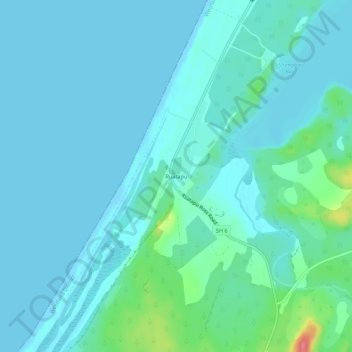
Name: Ruatapu topographic map, elevation, terrain.
Location: Ruatapu, Westland District, West Coast, 7883, New Zealand (-42.82847 170.86680 -42.78847 170.90680)
Average elevation: 36 ft
Minimum elevation: -3 ft
Maximum elevation: 256 ft
Other topographic maps
Click on a map to view its topography, its elevation and its terrain.
Totara Lagoon
Totara Lagoon, Paiere Road, Ruatapu, Westland District, West Coast, 7883, New Zealand
Average elevation: 33 ft
Ogilvie Lagoon
Ogilvie Lagoon, Ruatapu Ross Road, Ruatapu, Westland District, West Coast, 7812, New Zealand
Average elevation: 161 ft