
Make a donation
Gear up for your next adventure:
As an Amazon Associate, this site earns from qualifying purchases at no extra cost to you.
Norte de Santander topographic map
Click on the map to display elevation.
Make a donation
Gear up for your next adventure:
As an Amazon Associate, this site earns from qualifying purchases at no extra cost to you.
About this map
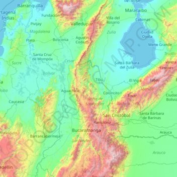
Name: Norte de Santander topographic map, elevation, terrain.
Location: Norte de Santander, Región Andina, Colombia (5.84179 -75.64925 11.04179 -70.44925)
Average elevation: 2,093 ft
Minimum elevation: -13 ft
Maximum elevation: 17,976 ft
Make a donation
Gear up for your next adventure:
As an Amazon Associate, this site earns from qualifying purchases at no extra cost to you.
Other topographic maps
Click on a map to view its topography, its elevation and its terrain.
Pacho
Pacho is a municipality and town of Colombia in the department of Cundinamarca. Pacho is part of the Rionegro Province and the urban centre is situated at a distance of 88 kilometres (55 mi) from the capital Bogotá at an altitude of 2,136 metres (7,008 ft), while the altitude ranges from 1,000 metres (3,300…
Average elevation: 6,171 ft
Make a donation
Gear up for your next adventure:
As an Amazon Associate, this site earns from qualifying purchases at no extra cost to you.
Quindío
With law 61 of 1985, the Colombian Congress adopted the Quindío wax palm tree, Ceroxylon quindiuense, a local endangered species adapted to high altitudes, as the National Tree. As ratified on September 16, 1985, by the then president of Colombia, Belisario Betancur, the law states: "The species commonly…
Average elevation: 6,749 ft
Nariño
Nariño has a diverse geography and varied climate according to altitude: hot in the plains of the Pacific and cold in the mountains, where most of the population resides, a situation that is repeated in a north-south direction. Other important cities include Tumaco and Ipiales.
Average elevation: 3,793 ft
Make a donation
Gear up for your next adventure:
As an Amazon Associate, this site earns from qualifying purchases at no extra cost to you.
Magdalena
The Department of Magdalena, because of its terrain, and proximity to the sea has an unstable weather. Its Climate is mainly dictated by its global positioning, and because the department of Magdalena is located on the Intertropical Convergence Zone it possess an inter-tropical climate. Temperature in the…
Average elevation: 1,335 ft
Bucaramanga
Bucaramanga is located on a plateau in the Cordillera Oriental of the Colombian Andes, and many residents occupy unstable lands descending steeply from the meseta. Westbound of it, the Rio de Oro Canyon is located at an altitude of 600 metres (2,000 ft) above sea level. Eastbound, the Andean Range rises up in…
Average elevation: 4,163 ft
Medellín
Medellín has 16 comunas (districts), 5 corregimientos (townships), and 271 barrios (neighborhoods). The metropolitan area of Medellín lies within the Aburrá valley at an elevation of 1,500 meters (4,900 feet) above sea level and is bisected by the Medellín River (also called Porce), which flows northward.…
Average elevation: 6,870 ft
Make a donation
Gear up for your next adventure:
As an Amazon Associate, this site earns from qualifying purchases at no extra cost to you.
Monterrey
The city of Monterrey is 540 metres (1,770 ft) above sea level in the northeastern state of Nuevo León. Monterrey translated from Spanish to English is "King Mount" or "King mountain", which refers to the city's topography and the large mountains that surround it. The Santa Catarina River—dry most of the…
Average elevation: 1,847 ft
Make a donation
Gear up for your next adventure:
As an Amazon Associate, this site earns from qualifying purchases at no extra cost to you.
Mosquera
Mosquera is a municipality of Colombia in the Western Savanna Province, part of the department of Cundinamarca. Mosquera is close to the capital Bogotá and is part of its metropolitan area. The urban centre of Mosquera is situated at an altitude of 2,516 metres (8,255 ft) on the Bogotá savanna. The…
Average elevation: 8,432 ft
Make a donation
Gear up for your next adventure:
As an Amazon Associate, this site earns from qualifying purchases at no extra cost to you.
Cali
Colombia > Valle del Cauca > Cali
Under Köppen's climate classification, Cali features a dry-summer tropical savanna climate (Köppen climate classification: As). The Western Mountain Range rises from an average of 2,000 m (6,562 ft) above sea level in the northern part of the city to approximately 4,000 m (13,123 ft) to the south. Because of…
Average elevation: 3,747 ft
Bogota Capital District - Municipality
The city is located in the center of Colombia, on a high plateau known as the Bogotá savanna, part of the Altiplano Cundiboyacense located in the Eastern Cordillera of the Andes. Its altitude averages 2,640 meters (8,660 ft) above sea level. Subdivided into 20 localities, Bogotá has an area of 1,587 square…
Average elevation: 7,162 ft
Make a donation
Gear up for your next adventure:
As an Amazon Associate, this site earns from qualifying purchases at no extra cost to you.
Antioquia
Due to its geographical isolation (as it is located among mountains), Antioquia suffered supply problems. Its topography did not allow for much agriculture, so the city became dependent upon trade, especially of gold and gin for the colonization of new land. Much of this trade was due to reforms passed after a…
Average elevation: 2,014 ft
Make a donation
Gear up for your next adventure:
As an Amazon Associate, this site earns from qualifying purchases at no extra cost to you.