
Remshalden topographic map
Click on the map to display elevation.
About this map
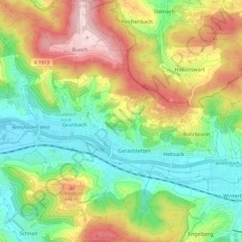
Name: Remshalden topographic map, elevation, terrain.
Location: Remshalden, Rems-Murr-Kreis, Baden-Württemberg, 73630, Germany (48.78849 9.40379 48.84565 9.47770)
Average elevation: 1,129 ft
Minimum elevation: 751 ft
Maximum elevation: 1,713 ft
Other topographic maps
Click on a map to view its topography, its elevation and its terrain.
Kleinhegnach
Germany > Baden-Württemberg > Rems-Murr-Kreis > Waiblingen > Neustadt
Average elevation: 909 ft
Dörnich
Germany > Baden-Württemberg > Rems-Murr-Kreis > Sulzbach an der Murr
Average elevation: 1,342 ft