
Thank you for supporting this site ❤️
Make a donation
Make a donation
Gear up for your next adventure:
As an Amazon Associate, this site earns from qualifying purchases at no extra cost to you.
Thiruporur topographic map
Click on the map to display elevation.
Thank you for supporting this site ❤️
Make a donation
Make a donation
Gear up for your next adventure:
As an Amazon Associate, this site earns from qualifying purchases at no extra cost to you.
About this map
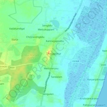
Name: Thiruporur topographic map, elevation, terrain.
Location: Thiruporur, Tiruporur, Chengalpattu, Tamil Nadu, 603105, India (12.68586 80.14952 12.76586 80.22952)
Average elevation: 23 ft
Minimum elevation: -7 ft
Maximum elevation: 112 ft
Thank you for supporting this site ❤️
Make a donation
Make a donation
Gear up for your next adventure:
As an Amazon Associate, this site earns from qualifying purchases at no extra cost to you.