
Hanshui River topographic map
Interactive map
Click on the map to display elevation.
About this map
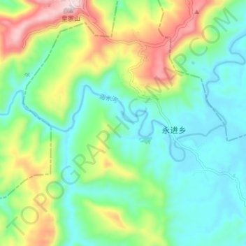
Name: Hanshui River topographic map, elevation, terrain.
Location: Hanshui River, Dachuan District, Dazhou City, Sichuan, PRC (31.33317 107.02937 31.35072 107.09604)
Average elevation: 1,388 ft
Minimum elevation: 945 ft
Maximum elevation: 2,385 ft
Other topographic maps
Click on a map to view its topography, its elevation and its terrain.
Wenchuan County
Wenchuan County, Ngawa Tibetan and Qiang Autonomous Prefecture, Sichuan, PRC
Average elevation: 9,104 ft
Jiuzhai Valley National Park
Jiuzhai Valley National Park, 日则沟, Zechawa, Jiuzhaigou County, Ngawa Tibetan and Qiang Autonomous Prefecture, Sichuan, PRC
Average elevation: 11,224 ft
Yanbian County
PRC > Sichuan > Panzhihua City
Yanbian County, Panzhihua City, Sichuan, PRC
Average elevation: 6,476 ft
Jialing River
Jialing River, Gaoping District, Nanchong City, Sichuan, 400000, PRC
Average elevation: 1,693 ft
Yalong River
Yalong River, Litang County, Garzê Tibetan Autonomous Prefecture, Sichuan, 615613, PRC
Average elevation: 11,083 ft