
Lago Gabiet topographic map
Interactive map
Click on the map to display elevation.
About this map
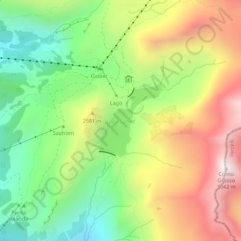
Name: Lago Gabiet topographic map, elevation, terrain.
Location: Lago Gabiet, 5, Batt, Gressoney-La-Trinité, Aosta Valley, Italy (45.84557 7.84493 45.85372 7.85500)
Average elevation: 7,982 ft
Minimum elevation: 6,440 ft
Maximum elevation: 9,908 ft
Other topographic maps
Click on a map to view its topography, its elevation and its terrain.
Monte Rosa Massif
Italy > Aosta Valley > Gressoney-La-Trinité
Monte Rosa Massif, Gressoney-La-Trinité, Aosta Valley, Italy
Average elevation: 11,411 ft
Edelboden inferiore
Italy > Aosta Valley > Gressoney-La-Trinité
Edelboden inferiore, Gressoney-La-Trinité, Aosta Valley, Italy
Average elevation: 7,110 ft