
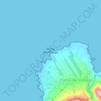
Punta del Hidalgo topographic map
Interactive map
Click on the map to display elevation.
About this map
Name: Punta del Hidalgo topographic map, elevation, terrain.
Average elevation: 56 ft
Minimum elevation: 0 ft
Maximum elevation: 840 ft
Other topographic maps
Click on a map to view its topography, its elevation and its terrain.
Las Nieves
España > Canarias > San Cristóbal de La Laguna > Las Nieves
Las Nieves, San Cristóbal de La Laguna, Santa Cruz de Tenerife, Canarias, 38329, España
Average elevation: 1,388 ft
El Gamonal
España > Canarias > San Cristóbal de La Laguna
El Gamonal, San Cristóbal de La Laguna, Santa Cruz de Tenerife, Canarias, 38293, España
Average elevation: 2,162 ft
Roque Dos Hermanos
España > Canarias > San Cristóbal de La Laguna
Roque Dos Hermanos, San Cristóbal de La Laguna, Santa Cruz de Tenerife, Canarias, 38240, España
Average elevation: 413 ft