
Streymoy topographic map
Interactive map
Click on the map to display elevation.
About this map
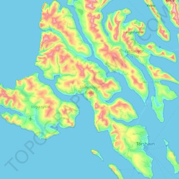
Name: Streymoy topographic map, elevation, terrain.
Location: Streymoy, Streymoy region, Faroe Islands (61.93813 -7.26072 62.30909 -6.73299)
Average elevation: 436 ft
Minimum elevation: -23 ft
Maximum elevation: 2,894 ft
Other topographic maps
Click on a map to view its topography, its elevation and its terrain.
Tórshavn
Faroe Islands > Streymoy region
Tórshavn, Streymoy region, 100, Faroe Islands
Average elevation: 223 ft
Vestmanna
Faroe Islands > Streymoy region
Vestmanna, Streymoy region, 350, Faroe Islands
Average elevation: 938 ft
Kirkjubøur
Faroe Islands > Streymoy region
Kirkjubøur, Streymoy region, 175, Faroe Islands
Average elevation: 157 ft
Saksun
Faroe Islands > Streymoy region
Saksun, Streymoy region, 436, Faroe Islands
Average elevation: 994 ft
Válur
Faroe Islands > Streymoy region > Válur
Válur, Streymoy region, 358, Faroe Islands
Average elevation: 587 ft
Streymoy
Faroe Islands > Streymoy region > Stykkið
Streymoy, Stykkið, Streymoy region, 330, Faroe Islands
Average elevation: 197 ft