
Ahden topographic map
Interactive map
Click on the map to display elevation.
About this map
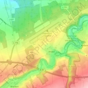
Name: Ahden topographic map, elevation, terrain.
Average elevation: 689 ft
Minimum elevation: 446 ft
Maximum elevation: 961 ft
Other topographic maps
Click on a map to view its topography, its elevation and its terrain.
Wewelsburg
Deutschland > Nordrhein-Westfalen > Büren > Büren > Wewelsburg
Wewelsburg, 17, Burgwall, Wewelsburg, Büren, Kreis Paderborn, Nordrhein-Westfalen, 33142, Deutschland
Average elevation: 709 ft
Brenken
Deutschland > Nordrhein-Westfalen > Büren
Brenken, Büren, Kreis Paderborn, Regierungsbezirk Detmold, Nordrhein-Westfalen, Deutschland
Average elevation: 784 ft