
Unering topographic map
Interactive map
Click on the map to display elevation.
About this map
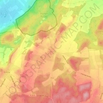
Name: Unering topographic map, elevation, terrain.
Average elevation: 2,087 ft
Minimum elevation: 1,785 ft
Maximum elevation: 2,260 ft
Other topographic maps
Click on a map to view its topography, its elevation and its terrain.
Wangen
Deutschland > Bayern > Landkreis Starnberg > Starnberg
Wangen, Starnberg, Landkreis Starnberg, Bayern, Deutschland
Average elevation: 2,093 ft
Starnberg
Deutschland > Bayern > Landkreis Starnberg
Starnberg, Landkreis Starnberg, Bayern, 82319, Deutschland
Average elevation: 2,070 ft