Refugi de Malniu topographic map
Interactive map
Click on the map to display elevation.
About this map
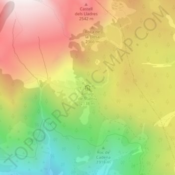
Name: Refugi de Malniu topographic map, elevation, terrain.
Average elevation: 7,119 ft
Minimum elevation: 5,272 ft
Maximum elevation: 8,858 ft

Click on the map to display elevation.
Name: Refugi de Malniu topographic map, elevation, terrain.
Average elevation: 7,119 ft
Minimum elevation: 5,272 ft
Maximum elevation: 8,858 ft