
Godavari topographic map
Interactive map
Click on the map to display elevation.
About this map
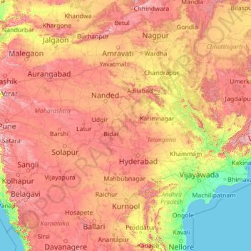
Name: Godavari topographic map, elevation, terrain.
Location: Godavari, Nizamabad, Telangana, 534452, India (16.68053 73.53222 20.05143 82.35356)
Average elevation: 1,247 ft
Minimum elevation: -7 ft
Maximum elevation: 4,724 ft
Other topographic maps
Click on a map to view its topography, its elevation and its terrain.
Gurudev Nagar
India > Telangana > Gurudev Nagar
Gurudev Nagar, Boath mandal, Adilabad, Telangana, India
Average elevation: 1,532 ft