
Caldwell County topographic map
Interactive map
Click on the map to display elevation.
About this map
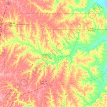
Name: Caldwell County topographic map, elevation, terrain.
Location: Caldwell County, Missouri, USA (39.52394 -94.21249 39.78817 -93.76187)
Average elevation: 906 ft
Minimum elevation: 712 ft
Maximum elevation: 1,063 ft
Other topographic maps
Click on a map to view its topography, its elevation and its terrain.
Point Lookout
USA > Missouri > Point Lookout
Point Lookout, Taney County, Missouri, 65726, USA
Average elevation: 863 ft
Mississippi River
Mississippi River, Audrain County, Missouri, 55455-0237, USA
Average elevation: 1,129 ft
Springfield
USA > Missouri > Springfield
Springfield, Greene County, Missouri, USA
Average elevation: 1,276 ft