
Thank you for supporting this site ❤️
Make a donation
Make a donation
Gear up for your next adventure:
As an Amazon Associate, this site earns from qualifying purchases at no extra cost to you.
Konnakad topographic map
Click on the map to display elevation.
Thank you for supporting this site ❤️
Make a donation
Make a donation
Gear up for your next adventure:
As an Amazon Associate, this site earns from qualifying purchases at no extra cost to you.
About this map
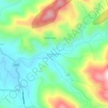
Name: Konnakad topographic map, elevation, terrain.
Location: Konnakad, Vellarikkundu, Kasaragod district, Kerala, India (12.34734 75.35359 12.38734 75.39359)
Average elevation: 889 ft
Minimum elevation: 269 ft
Maximum elevation: 2,106 ft
Thank you for supporting this site ❤️
Make a donation
Make a donation
Gear up for your next adventure:
As an Amazon Associate, this site earns from qualifying purchases at no extra cost to you.