Geolocate

Natal topographic map

Click on the map to display elevation.

About this map

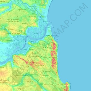
Name: Natal topographic map, elevation, terrain.

Location: Natal, Região Geográfica Imediata de Natal, Região Geográfica Intermediária de Natal, Rio Grande do Norte, Northeast Region, Brazil (-5.90021 -35.29124 -5.70274 -35.15310)

Average elevation: 69 ft

Minimum elevation: -7 ft

Maximum elevation: 358 ft

Other topographic maps

Click on a map to view its topography, its elevation and its terrain.

Morro do Careca

Brazil > Rio Grande do Norte > Natal

Average elevation: 82 ft

Natal

Brazil > Rio Grande do Norte > Natal

Average elevation: 69 ft

Gear up for your next adventure:

🌐World Map Poster - Decorative world maps with topographic info
🛶Inflatable Kayak - Portable kayak for rivers, lakes, and expeditions
🎒Outdoor Daypacks - Lightweight backpacks designed for carrying maps and essential gear
🔌USB Car Charger - Car charger for on‑the‑go power needs
🧯Portable Fire Pit - Compact fire pit for camping spots

As an Amazon Associate, this site earns from qualifying purchases at no extra cost to you.