Geolocate

Province of Bellavista topographic map

Click on the map to display elevation.

About this map

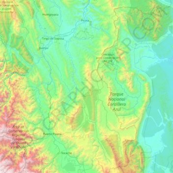
Name: Province of Bellavista topographic map, elevation, terrain.

Location: Province of Bellavista, San Martín, Peru (-8.37961 -76.73621 -6.72538 -75.82949)

Average elevation: 2,785 ft

Minimum elevation: 495 ft

Maximum elevation: 13,848 ft

Other topographic maps

Click on a map to view its topography, its elevation and its terrain.

Morro de Calzada

Peru > San Martín > Calzada > Calzada

Average elevation: 3,153 ft

Rey del Valle

Peru > San Martín > Alonso de Alvarado

Average elevation: 3,927 ft

Guantanamo

Peru > San Martín

Average elevation: 1,834 ft

San Andrés

Peru > San Martín > Jepelacio

Average elevation: 4,183 ft

La Unión

Peru > San Martín > La Banda de Shilcayo

Average elevation: 1,407 ft

Gear up for your next adventure:

🏕️Tent Footprint - Protect your tent base from wear
🔦Compact Flashlight - Reliable flashlight for emergencies
☀️Outdoor Sunscreen - High protection sunscreen for outdoor activities
🧺Microfiber Travel Towels - Compact and fast-drying towels for trail use
🪶Multi‑Purpose Knife - Useful blade for camp and trail

As an Amazon Associate, this site earns from qualifying purchases at no extra cost to you.