
La Grange topographic map
Interactive map
Click on the map to display elevation.
About this map
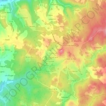
Name: La Grange topographic map, elevation, terrain.
Average elevation: 597 ft
Minimum elevation: 394 ft
Maximum elevation: 768 ft
Other topographic maps
Click on a map to view its topography, its elevation and its terrain.
Bois de Vinssou
France > Nouvelle-Aquitaine > Dordogne > Biron > Vinsou
Bois de Vinssou, Vinsou, Biron, Bergerac, Dordogne, Nouvelle-Aquitaine, France métropolitaine, 24540, France
Average elevation: 584 ft
Plaisance
France > Nouvelle-Aquitaine > Dordogne > Biron
Plaisance, Biron, Bergerac, Dordogne, Nouvelle-Aquitaine, France métropolitaine, 24540, France
Average elevation: 633 ft
Les Mounards
France > Nouvelle-Aquitaine > Dordogne > Biron
Les Mounards, Biron, Bergerac, Dordogne, Nouvelle-Aquitaine, France métropolitaine, 24540, France
Average elevation: 633 ft
Le Bout du Parc
France > Nouvelle-Aquitaine > Dordogne > Biron
Le Bout du Parc, Biron, Bergerac, Dordogne, Nouvelle-Aquitaine, France métropolitaine, 24540, France
Average elevation: 630 ft