
Make a donation
Gear up for your next adventure:
As an Amazon Associate, this site earns from qualifying purchases at no extra cost to you.
São Bento do Sapucaí topographic map
Click on the map to display elevation.
Make a donation
Gear up for your next adventure:
As an Amazon Associate, this site earns from qualifying purchases at no extra cost to you.
São Bento do Sapucaí
Located 164 km northeast of São Paulo, on a mountain chain called Serra da Mantiqueira, it has a total area of 251.2 km2. The topography is very mountainous. There are many hills and waterfalls (the highest being Toldi Falls with more than 200 m). The city's average altitude is 886 meters, and the highest peak is a rock compound known as Pedra do Baú with an elevation of 1,950 metres (6,400 ft).
Make a donation
Gear up for your next adventure:
As an Amazon Associate, this site earns from qualifying purchases at no extra cost to you.
About this map
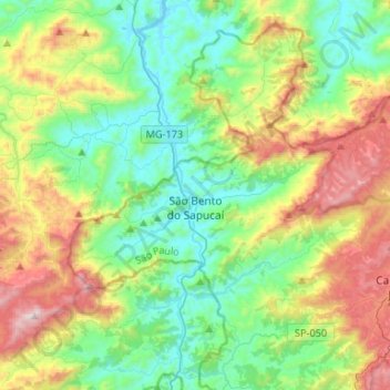
Name: São Bento do Sapucaí topographic map, elevation, terrain.
Average elevation: 4,019 ft
Minimum elevation: 2,785 ft
Maximum elevation: 6,732 ft
Make a donation
Gear up for your next adventure:
As an Amazon Associate, this site earns from qualifying purchases at no extra cost to you.
Other topographic maps
Click on a map to view its topography, its elevation and its terrain.
São Francisco Xavier
Brazil > São Paulo > Região Metropolitana do Vale do Paraíba e Litoral Norte > São José dos Campos
Average elevation: 2,795 ft
São José dos Campos
Brazil > São Paulo > Região Metropolitana do Vale do Paraíba e Litoral Norte > São José dos Campos
In the urban area, there are rolling plateaus and hills. The lowest elevation in the city (and also in the municipality) is found in the Paraíba do Sul River, at a mean elevation of 550 m.
Average elevation: 2,080 ft