
Town of Lumberland topographic map
Interactive map
Click on the map to display elevation.
About this map
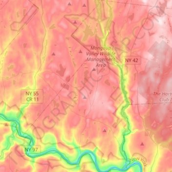
Name: Town of Lumberland topographic map, elevation, terrain.
Location: Town of Lumberland, Sullivan County, New York, United States (41.42146 -74.90445 41.60478 -74.75044)
Average elevation: 1,181 ft
Minimum elevation: 430 ft
Maximum elevation: 1,637 ft
Lumberland is located within the Upper Delaware Scenic and Recreational River. Elevations range from approximately 600 feet near the Delaware River to over 1,300 feet above sea level on the bluffs overlooking the Delaware, and where the Catskill Mountains begin to rise in the northern reaches of the town. The terrain is largely mountainous and wooded, with the majority of residents settling close to or on main roads, such as New York State Route 97 (Upper Delaware Scenic Byway).
Other topographic maps
Click on a map to view its topography, its elevation and its terrain.
Mongaup Valley
United States > New York > Sullivan County > Town of Bethel
Mongaup Valley, Town of Bethel, Sullivan County, New York, United States
Average elevation: 1,247 ft
Town of Forestburgh
United States > New York > Sullivan County
Town of Forestburgh, Sullivan County, New York, 12777, United States
Average elevation: 1,309 ft
Woodbourne
United States > New York > Sullivan County > Town of Fallsburg
Woodbourne, Town of Fallsburg, Sullivan County, New York, United States
Average elevation: 1,293 ft
Anderson
United States > New York > Sullivan County > Town of Rockland
Anderson, Town of Rockland, Sullivan County, New York, 12768, United States
Average elevation: 2,008 ft
Village of Liberty
United States > New York > Sullivan County
Village of Liberty, Town of Liberty, Sullivan County, New York, 12754, United States
Average elevation: 1,627 ft
Town of Delaware
United States > New York > Sullivan County
Town of Delaware, Sullivan County, New York, United States
Average elevation: 1,220 ft
Hankins
United States > New York > Sullivan County
Hankins, Town of Fremont, Sullivan County, New York, United States
Average elevation: 1,089 ft
Town of Liberty
United States > New York > Sullivan County
Town of Liberty, Sullivan County, New York, United States
Average elevation: 1,673 ft
Livingston Manor
United States > New York > Sullivan County > Town of Rockland
Livingston Manor, Town of Rockland, Sullivan County, New York, 12758, United States
Average elevation: 1,690 ft
Eldred
United States > New York > Sullivan County > Eldred
Eldred, Town of Highland, Sullivan County, New York, United States
Average elevation: 1,152 ft
Town of Fallsburg
United States > New York > Sullivan County
Town of Fallsburg, Sullivan County, New York, United States
Average elevation: 1,365 ft
Monticello
United States > New York > Sullivan County > Monticello
Monticello, Town of Thompson, Sullivan County, New York, 12701, United States
Average elevation: 1,457 ft
Parksville
United States > New York > Sullivan County > Town of Liberty
Parksville, Town of Liberty, Sullivan County, New York, 12768, United States
Average elevation: 1,896 ft