Geolocate

Porangatu topographic map

Click on the map to display elevation.

Porangatu

Important rivers are the Santa Tereza, Cana Brava, Ouro Pintado, Santa Maria and Gregório. The climate is hot, moist tropical, with frequent occurrences of a maximum of 40 °C. The average minimum is 21C, the maximum is 40 °C and the minimum is 21 °C. The elevation is 390 meters above sea level and the highest points are Serra da Sabina and Serra dos Picos.

Wikipedia (CC-BY-SA 3.0)

About this map

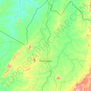
Name: Porangatu topographic map, elevation, terrain.

Location: Porangatu, Região Geográfica Imediata de Porangatu, Região Geográfica Intermediária de Porangatu-Uruaçu, Goiás, Central-West Region, Brazil (-13.77038 -49.72038 -12.79000 -48.81907)

Average elevation: 1,145 ft

Minimum elevation: 732 ft

Maximum elevation: 3,219 ft

Gear up for your next adventure:

🎒Waterproof Dry Bags - Keep your electronics and maps dry inside your pack
🎒Trekking Poles - Sturdy poles for balance and stability on rough terrain
🌧️Backpack Rain Cover - Keep gear dry in wet weather
🧥Waterproof Jacket for Hiking - Breathable and rugged rain jacket for outdoor excursions
🛌Ultralight Sleeping Bags - Compact down bags for cold nights in the wilderness

As an Amazon Associate, this site earns from qualifying purchases at no extra cost to you.