
Shap topographic map
Click on the map to display elevation.
About this map
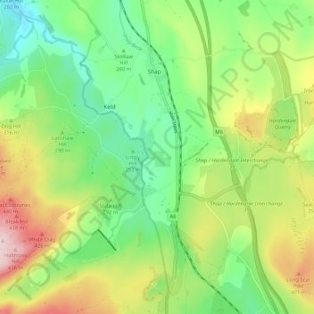
Name: Shap topographic map, elevation, terrain.
Location: Shap, Westmorland and Furness, England, United Kingdom (54.48382 -2.70097 54.54355 -2.65485)
Average elevation: 988 ft
Minimum elevation: 620 ft
Maximum elevation: 1,601 ft
Other topographic maps
Click on a map to view its topography, its elevation and its terrain.
Walney Channel
United Kingdom > England > Westmorland and Furness > Roa Island
Average elevation: 13 ft
Pendragon Castle
United Kingdom > England > Westmorland and Furness > Outhgill
Average elevation: 1,132 ft
Kearstwick
United Kingdom > England > Westmorland and Furness > South Lakeland > Kirkby Lonsdale
Average elevation: 312 ft