
米林县 topographic map
Interactive map
Click on the map to display elevation.
About this map
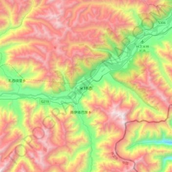
Name: 米林县 topographic map, elevation, terrain.
Location: 米林县, 米林镇, 米林县, 林芝市, 西藏自治区, 中国 (29.05596 94.05146 29.37596 94.37146)
Average elevation: 12,621 ft
Minimum elevation: 8,415 ft
Maximum elevation: 17,297 ft
米林县位于西藏东南部,雅鲁藏布江中游河谷地带,在念青唐古拉山脉与喜马拉雅山脉之间。全县平均海拔3700米,县政府所在地米林镇海拔约为2940米。