Geolocate

Dinant topographic map

Click on the map to display elevation.

About this map

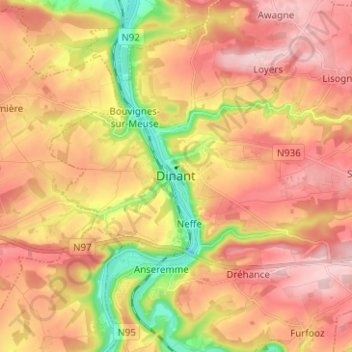
Name: Dinant topographic map, elevation, terrain.

Location: Dinant, Namur, Wallonia, 5500, Belgium (50.21918 4.87306 50.29918 4.95306)

Average elevation: 669 ft

Minimum elevation: 249 ft

Maximum elevation: 965 ft

Gear up for your next adventure:

👟Trail Running Shoes - Lightweight shoes for trail runners
😴Insulated Sleeping Pads - Compact and warm pads for high-elevation camping
🥾Men's Hiking Boots - Durable, waterproof footwear for rugged terrain and steep inclines
🕶️Glacier Sunglasses - Side shields to protect eyes from high-altitude snow glare
🧭Pro Hiking Compasses - High-accuracy liquid-filled compasses for topographic orientation

As an Amazon Associate, this site earns from qualifying purchases at no extra cost to you.