
La Treflière topographic map
Interactive map
Click on the map to display elevation.
About this map
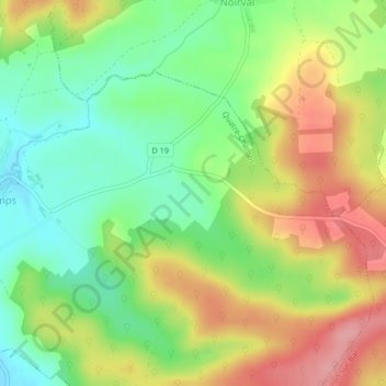
Name: La Treflière topographic map, elevation, terrain.
Average elevation: 584 ft
Minimum elevation: 417 ft
Maximum elevation: 787 ft
Other topographic maps
Click on a map to view its topography, its elevation and its terrain.
Bois du Chemin de Boult
France > Grand Est > Ardennes > Quatre-Champs
Bois du Chemin de Boult, Quatre-Champs, Vouziers, Ardennes, Grand Est, France métropolitaine, 08400, France
Average elevation: 587 ft