
Filton topographic map
Interactive map
Click on the map to display elevation.
About this map
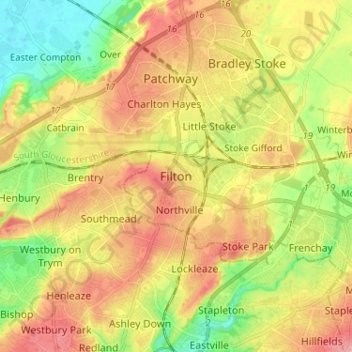
Name: Filton topographic map, elevation, terrain.
Average elevation: 187 ft
Minimum elevation: 13 ft
Maximum elevation: 358 ft
Other topographic maps
Click on a map to view its topography, its elevation and its terrain.
Filton
United Kingdom > England > Filton
Filton, South Gloucestershire, South West England, England, BS34, United Kingdom
Average elevation: 223 ft