
Klein Ottersleben topographic map
Interactive map
Click on the map to display elevation.
About this map
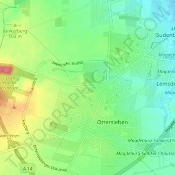
Name: Klein Ottersleben topographic map, elevation, terrain.
Location: Klein Ottersleben, Magdeburg, Saxe-Anhalt, 39116, Allemagne (52.07731 11.54723 52.11731 11.58723)
Average elevation: 279 ft
Minimum elevation: 190 ft
Maximum elevation: 446 ft
Other topographic maps
Click on a map to view its topography, its elevation and its terrain.
Diesdorf
Allemagne > Saxe-Anhalt > Klein Ottersleben
Diesdorf, Klein Ottersleben, Magdeburg, Saxe-Anhalt, Allemagne
Average elevation: 243 ft